


Paddle Ways - Lets Go Paddling
3.9129.00 Reviews
App Specs
- Version
- 3.1.8
- Updated On
- License
- Free
- Downloads
- 10,000+
- Developer
- onwater llc
- Categories
- Maps & Navigation
- Platform
- Android
Screenshots
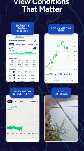
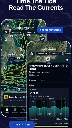
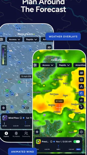
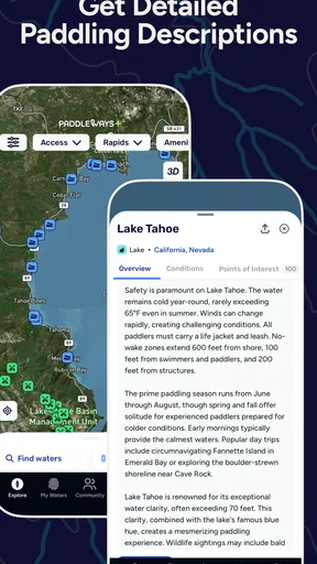
 Analysis by AppCompare
I’ve found that paddling apps are most useful before a trip, when I’m trying to turn “that stretch of water looks inviting” into a sensible plan. Paddle Ways - Lets Go Paddling is aimed at that moment: it is a free Maps & Navigation app from onwater llc, centered on waterways, paddling locations and conditions. I’d treat it as a planning companion rather than a substitute for local knowledge or sound judgment on the water.
The first practical question is whether it helps with the kind of outing you actually take. A short, familiar paddle calls for less preparation than a full day on an unfamiliar river or lake. I find the app’s focus most useful when I want to explore a new launch area, compare possible routes, or get a clearer sense of what to check before leaving home. It is less compelling if I only need general driving directions or a basic street map.
Where setup and expectations can trip you up
With any navigation app, the first disappointment can come from expecting it to answer every question at once. A map can help orient a trip, but it does not make a route safe by itself. Water levels, wind, access rules, obstacles and the paddler’s own ability all affect whether a plan makes sense. I would use the app to guide research, then check current local conditions before committing to a launch.
It also helps to distinguish finding a place from knowing what the day will be like there. A route that looks manageable on a screen may feel very different with a headwind, changing water or a tired group. For a first visit, I’d make the initial outing conservative: choose a shorter plan, leave room to turn back, and avoid treating a mapped line as a promise about difficulty.
The app is rated for Everyone, which makes it approachable as a general-use product, but that should not be confused with advice for every age or ability on the water. Parents, new paddlers and anyone bringing a mixed-experience group still need to decide whether the destination, equipment and supervision are suitable. The app can support that decision; it cannot make it on your behalf.
Simple checks before you leave
Before relying on a map at the launch, I’d open the app while I still have a stable connection and look over the area rather than waiting until I’m already on the water. Confirm that you are viewing the intended river or lake, identify the access point you plan to use, and note a reasonable alternative if the first choice does not work out. That small bit of preparation can prevent a rushed decision at the shoreline.
I’d also make sure my phone has enough charge for the outing and that I know how I’ll navigate if the device becomes unavailable. A paper map, a downloaded reference where available, or a route written down can be a sensible backup depending on the trip. This is especially worthwhile when travelling with others: agree on the destination and turnaround plan before anyone sets off, instead of relying on everyone to interpret the same screen later.
Worth Reading Before You Choose

Flipboard Shows What News Apps Must Do Beyond the Feed

Switching to Android Auto Means Rethinking Your Driving Routine

Google Calendar Makes a Crowded Week Easier to Manage

Ludo King Makes the Most of the Minutes Between Plans

Baby Panda World Brings Quick Play to Modern Phones, but Its Game Library Feels Busy

ESPN’s Live Game View Makes Following Close Games Easier
For a lake day, I might use the app to narrow down where to explore, then check the forecast and ask locally about exposed sections before choosing a route. On a river, I’d be more cautious about assuming that a line on a map tells the whole story. Recent conditions and local hazards can change what is suitable, so I’d treat the app as one part of a wider check rather than my only source.
Discovering New Waters
Now, what’s the first thing you do when you download a new app? Right, you open it up and see what it’s all about. With Paddle Ways - Lets Go Paddling, I was greeted with a clean and intuitive interface. It’s like the developers knew exactly what I needed before I even did. The home screen neatly lays out all the options, making navigation smooth and easy.
Features That Make Waves
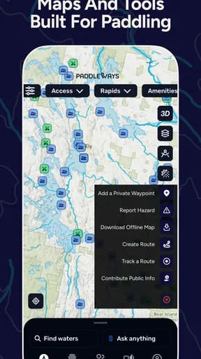
First up, let’s talk about the features. This app isn’t just about finding places to paddle; it’s like your personal paddling assistant. You can find detailed maps of waterways, which is a lifesaver if you’re venturing into new territories. The maps are super detailed, showing not just the routes but also the difficulty levels. So, whether you’re a newbie or a seasoned paddler, there’s something for everyone.
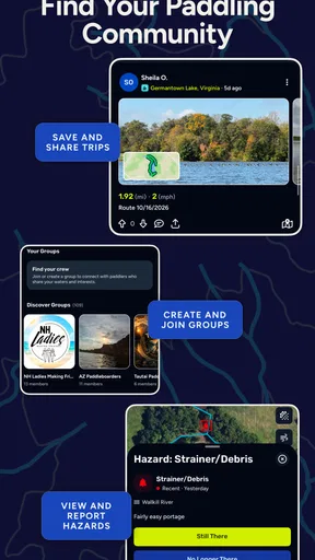
But wait, there’s more! A feature I found particularly cool is the community aspect. You can connect with other paddlers, share your routes, and even get tips. It’s like a social network for paddling enthusiasts. I stumbled upon a group planning a weekend paddling trip and got some awesome tips on gear and safety. This kind of interaction is what makes the app stand out.
Making the map useful for a real outing
One useful way to approach a new area is to use the map for comparison, not just selection. I’d look at a couple of possible places, then ask which one fits the people and time available that day. A sheltered lake might suit a relaxed afternoon better than an exposed route, while a more experienced group may want a longer outing. The app can help bring options into view; the final choice still depends on conditions and comfort level.
Community advice can add context that a map alone cannot provide, but I would read it as another perspective rather than a guarantee. A tip that worked for one paddler may reflect a different craft, season, water level or skill set. I’d use shared recommendations to generate questions—where do people launch, what should I watch for, is there a practical turnaround point?—then verify anything important before travelling.
That distinction matters when planning with friends. If one person finds a route and sends it to the group, everyone should still know the basic plan: where to meet, what stretch is intended, and when to reconsider. A shared route is a helpful conversation starter, not a replacement for agreeing on the day’s limits. In my view, that is one of the better ways to get value from a paddling community without following advice blindly.
Tracking and Safety
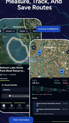
Safety first, right? The app offers real-time tracking, which is not just a nice-to-have but a must-have. Imagine being stuck somewhere and not knowing exactly where you are; that’s a nightmare. With this feature, you can share your location with friends or family, ensuring that someone always knows where you are.
Plus, I love the weather updates and alerts. Before heading out, you can check the weather conditions for your chosen route. Knowing there’s a storm coming can be a real game changer, and it’s always better to be prepared than caught off guard.
For everyday use, I would still tell someone the plan directly rather than assuming a tracking screen will do all the work. Agree on who is checking in and when, and keep a backup way to communicate if the phone is out of reach or loses service. On the water, conditions can change faster than a casual plan; if the forecast or the group’s energy gives you a reason to stop, changing course is better than pressing on just because the route is already mapped.
Recovering when the plan stops working
If something seems off, I’d first separate an app problem from a trip-planning problem. Check that the correct location is open and that the phone is behaving normally; then reconsider whether the route still makes sense in the conditions you can see. If the map does not settle the question, pause and use another reliable source or local guidance instead of repeatedly refreshing and hoping the screen resolves a safety concern.
A practical recovery plan is to know a simple way back before setting out. For a loop or a longer route, identify a conservative point where the group can turn around. If the chosen launch is inaccessible or the conditions are poor, having a second nearby option can save time, but do not treat a substitute location as automatically suitable. Check access and conditions there too.
When the phone itself is the issue, conserve its battery and avoid making it the only record of the plan. Keep the meeting point and return expectation clear among the group. If you are paddling alone, tell someone your intended area and when you expect to be back before you launch. These are ordinary precautions, but they matter more than any single app feature.
Getting the Most Out of Your Paddling Experience
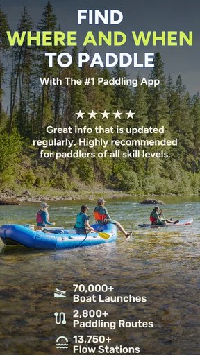
So, who’s this app really for? Honestly, anyone who loves to paddle. From beginners looking for easy trails to experienced paddlers hunting for a challenge, it caters to all levels. The app’s database is extensive, covering a wide range of locations, which means you’re bound to find something near you or maybe discover a hidden gem you never knew existed.
In addition to location discovery, the app’s integration with gear shops is pretty neat. If you suddenly realize you’re missing something essential, you can easily find nearby shops that cater to paddlers. It’s a small feature, but immensely helpful when you need it the most.
I think it is best suited to people who paddle often enough to benefit from discovering places and comparing options, as well as newcomers who want a starting point for planning. A realistic use would be deciding on a weekend lake outing: I’d check possible areas during the week, discuss the choice with the group, then confirm conditions and access before driving out. That workflow uses the app to reduce guesswork without asking it to make the safety decision.
It may be the wrong fit if your main need is turn-by-turn road navigation, detailed trip logging, or an authoritative source for current water hazards. A general map app may be more convenient for driving to a launch, while local agencies or experienced paddlers may be better for time-sensitive access and hazard questions. I would not expect one paddling-focused app to replace those tools; the advantage here is having water-oriented discovery and planning in one place.
There is also a cost detail worth noticing before you settle into a routine: the app is free to download, with optional in-app purchases listed from $9.99 to $49.99 per item. I’d start with the free experience and decide whether any paid option is useful for the way I paddle, rather than assuming I need to buy something before I can judge the app. The current version is 3.1.0, and it requires operating system 11 or later, so checking device compatibility before installation can prevent an avoidable setup snag.
Its average rating is 4.1 from 303 ratings, with 121 written reviews, and it has passed 10,000 installs. Those figures suggest that it has found an audience, but I would put more weight on whether its maps and planning approach fit the places you actually paddle. The developer, onwater llc, has made a focused tool; the most useful test is opening it for a real destination you have in mind and seeing whether it helps you plan more thoughtfully.
When another source should take the lead
There are situations where I would use Paddle Ways as a secondary reference. If a route depends on a current closure, a fast-changing river condition or a local access rule, I’d seek a current, authoritative source before setting off. Likewise, if a trip involves unfamiliar hazards or a group member with limited experience, local expertise and conservative judgment matter more than a convenient map display.
For a straightforward outing on familiar water, that caution need not make planning complicated. I’d use the app to refresh my sense of the area, keep the route modest, and confirm the basics with the people going. For a demanding or unfamiliar trip, I’d expand the preparation and make sure the app is only one layer of it. That difference—casual discovery versus serious route planning—is important when deciding how much to rely on any navigation tool.
Final Thoughts
All in all, Paddle Ways - Lets Go Paddling has really impressed me. It’s not just an app; it’s a companion for anyone who loves the thrill of paddling. The combination of features, from detailed maps to community engagement, makes it a must-have for paddling enthusiasts.
So, if you’re ready to explore new waters, meet fellow paddlers, and make sure you’re always safe and prepared, this app should be your go-to. Dive in and let the paddling adventures begin!
My practical verdict
I’d recommend giving it a try if finding places to paddle is part of the fun for you, especially when you want ideas beyond the water you already know. Its maps and community angle can help turn a vague outing into a plan, and the free entry point makes it easy to see whether it suits your routine. I would keep my expectations grounded: it helps organize a paddle, but it cannot promise that a route is open, safe or right for every group.
Before installing, check that your device meets the operating-system requirement. Before each trip, confirm the location and current conditions, tell someone the plan, and bring a backup approach for navigation and communication. If you mainly need road directions or live, authoritative hazard information, another source should take the lead. For paddlers who want a practical way to explore waterways and prepare more deliberately, though, it is a worthwhile place to start.
Pros
- Intuitive controls for easy navigation.
- Beautiful graphics enhance the experience.
- Multiplayer mode for social interaction.
- Frequent updates with new challenges.
- Lightweight app
- doesn't consume much space.
Cons
- Limited customization options for players.
- Requires stable internet for multiplayer.
- In-app ads can disrupt gameplay.
- Some levels feel repetitive over time.
- Limited offline functionality.
FAQs for Paddle Ways - Lets Go Paddling
What is Paddle Ways - Lets Go Paddling?
Paddle Ways - Lets Go Paddling is a mobile app designed for paddling enthusiasts, offering tools and resources to enhance your paddling experience. It features GPS tracking, weather forecasts, and route planning for kayaking, canoeing, and paddleboarding. Whether you're a beginner or an experienced paddler, this app provides valuable insights and tips.
Is Paddle Ways available for both Android and iOS devices?
Yes, Paddle Ways - Lets Go Paddling is available for download on both Android and iOS platforms. You can easily find it on the Google Play Store for Android devices and the Apple App Store for iOS devices. The app is designed to offer a seamless experience across both operating systems.
Does Paddle Ways offer offline access to maps and routes?
Yes, Paddle Ways provides offline access to maps and routes, allowing you to download your planned paddling paths before heading out. This feature is particularly useful in areas with limited or no internet connectivity, ensuring you can navigate safely and efficiently without relying on a mobile signal.
Are there any social features in Paddle Ways for connecting with other paddlers?
Indeed, Paddle Ways includes social features that allow users to connect with fellow paddlers. You can share your routes, join paddling groups, and participate in community events through the app. This fosters a sense of community and provides opportunities to learn from and connect with other paddling enthusiasts.
What are the safety features included in Paddle Ways?
Paddle Ways includes several safety features to ensure a secure paddling experience. These include real-time weather updates, tide and current information, and an emergency alert system that allows you to quickly notify contacts if you encounter trouble. These features are designed to help you plan safer and more enjoyable paddling trips.


